
Fuerteventura Nature & Landscape
Sightseeing Fuerteventura
Sightseeing
The most beautiful places on Fuerteventura where you can enjoy spectacular views
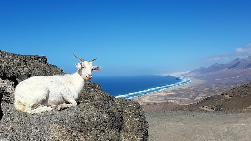
Cofete is a small village in the southwestern part of Fuerteventura on the Jandia peninsula on Fuerteventura. The beach at Cofete is approximately 35 km long. So you can walk along the tide line and enjoy the sea. The beach is surrounded by mountains that sometimes almost end up in the sea. Really worth a visit.
89 recommandé par les habitants
Cofete
Cofete is a small village in the southwestern part of Fuerteventura on the Jandia peninsula on Fuerteventura. The beach at Cofete is approximately 35 km long. So you can walk along the tide line and enjoy the sea. The beach is surrounded by mountains that sometimes almost end up in the sea. Really worth a visit.
In the north of the municipality of Betancuria, on the mountainside, there are two giant statues of Ayose and Guise, these are two former rulers on Fuerteventura. There are two parking ports for your car and it is a unique place to take pictures of the images, but more importantly you have a view of the north and south. Close to the statues there is a narrow road that leads to the Mirador de Morro Velosa a lookout post (building) designed by the famous architect, Caesar Manrique. The building houses a museum dedicated to the arid landscape of Fuerteventura and there is also a small café. Parking and admission are free. There is also a spectacular view of the center and north of Fuerteventura from the building. Tues to Sat from 10 am to 6 pm. To the south of Betancuria, on the road to Pajara, there are also a number of Miradors with parking spaces. These Miradors overlook the east and south of the island.
189 recommandé par les habitants
Betancuria
In the north of the municipality of Betancuria, on the mountainside, there are two giant statues of Ayose and Guise, these are two former rulers on Fuerteventura. There are two parking ports for your car and it is a unique place to take pictures of the images, but more importantly you have a view of the north and south. Close to the statues there is a narrow road that leads to the Mirador de Morro Velosa a lookout post (building) designed by the famous architect, Caesar Manrique. The building houses a museum dedicated to the arid landscape of Fuerteventura and there is also a small café. Parking and admission are free. There is also a spectacular view of the center and north of Fuerteventura from the building. Tues to Sat from 10 am to 6 pm. To the south of Betancuria, on the road to Pajara, there are also a number of Miradors with parking spaces. These Miradors overlook the east and south of the island.
LAS DUNAS NATIONAL PARK
The white sand of the dunes is on both sides of the FV-1 route towards Corralejo and you can enter it at the indicated locations along the way. There you have the opportunity to walk through the sand dunes or to stroll along the sandy beaches. There are free parking spaces on the sides of the road.
96 recommandé par les habitants
Parc naturel de Corralejo
LAS DUNAS NATIONAL PARK
The white sand of the dunes is on both sides of the FV-1 route towards Corralejo and you can enter it at the indicated locations along the way. There you have the opportunity to walk through the sand dunes or to stroll along the sandy beaches. There are free parking spaces on the sides of the road.
On the Fuerteventura peninsula called Jandia, a hiking route has been plotted. If you want to brave the 817 meter high mountain, you will get to see the most spectacular view of the entire island. (provided the weather is nice of course) You will have to walk for almost 3.5 hours so bring enough water and put on good and sturdy shoes. The walking route runs along beautiful vistas, so don't forget to bring your camera. (There is road sign on the route)
Bus line 03 - Ri Pto. del Rosario (station transfer)
Bus line 01 - Pto. del Rosario - Morro Jable
15 recommandé par les habitants
Pico de las Zarzas
On the Fuerteventura peninsula called Jandia, a hiking route has been plotted. If you want to brave the 817 meter high mountain, you will get to see the most spectacular view of the entire island. (provided the weather is nice of course) You will have to walk for almost 3.5 hours so bring enough water and put on good and sturdy shoes. The walking route runs along beautiful vistas, so don't forget to bring your camera. (There is road sign on the route)
Bus line 03 - Ri Pto. del Rosario (station transfer)
Bus line 01 - Pto. del Rosario - Morro Jable
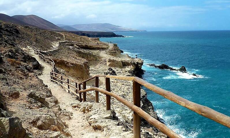
This typical Canarian fishing village is located on a bay on the west coast, enclosed by a few impressive cliffs and caves that have been carved into volcanic stone by the thunderous sea over the centuries.
In geological terms, this part of the island is special for more reasons: volcanic rock was found to be the oldest in the Canary Islands and even older than the island itself.
Take the footpath that goes up from the beach (north side).
This is the start of the hiking route to the caves.
Always keep left. There is a viewing platform just after the lime kilns.
If you walk further you can see the light and dark layers of the earth from different eras.
The further you walk, the calmer it becomes.
Further down the Caleta Negra the sea caves are coming into view. A slippery staircase descends to an impressive cave vault and a beach at the bottom of the steep rock face.
At low tide you can walk into the caves a bit, but keep an eye on the tide.
If you walk further, you will arrive at Pena Horadada, a rock gate formed by erosion.
Follow the same route on the way back, but then take the higher path from where you have a beautiful view of Ajuy and the beach.
76 recommandé par les habitants
Ajuy
This typical Canarian fishing village is located on a bay on the west coast, enclosed by a few impressive cliffs and caves that have been carved into volcanic stone by the thunderous sea over the centuries.
In geological terms, this part of the island is special for more reasons: volcanic rock was found to be the oldest in the Canary Islands and even older than the island itself.
Take the footpath that goes up from the beach (north side).
This is the start of the hiking route to the caves.
Always keep left. There is a viewing platform just after the lime kilns.
If you walk further you can see the light and dark layers of the earth from different eras.
The further you walk, the calmer it becomes.
Further down the Caleta Negra the sea caves are coming into view. A slippery staircase descends to an impressive cave vault and a beach at the bottom of the steep rock face.
At low tide you can walk into the caves a bit, but keep an eye on the tide.
If you walk further, you will arrive at Pena Horadada, a rock gate formed by erosion.
Follow the same route on the way back, but then take the higher path from where you have a beautiful view of Ajuy and the beach.