
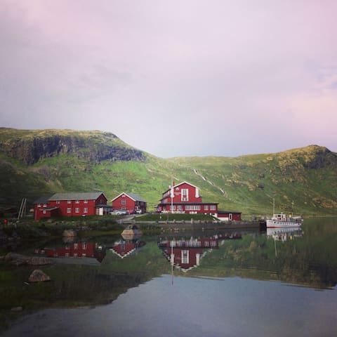
Summer at Tindeblikkhytta
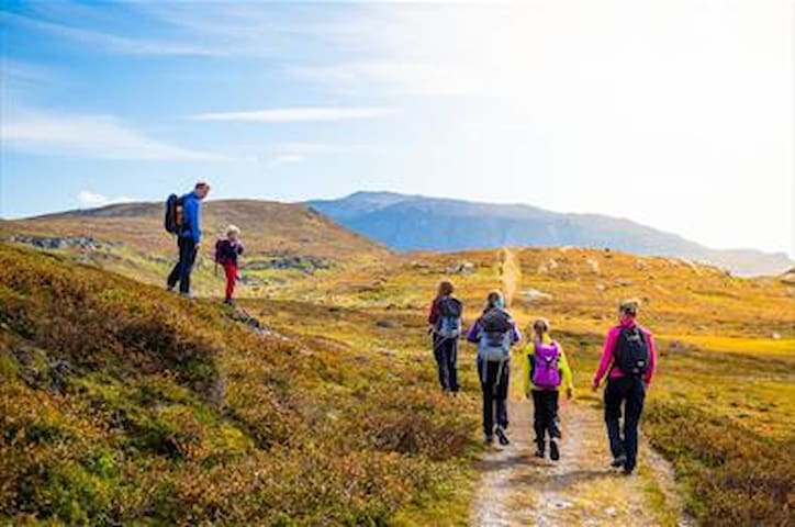
Great starting-points for short and long hikes
Feel like a long hike or a short stroll? Here are the best places park your car to start your adventure
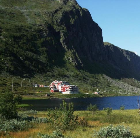
1h 40min drive from cabin. Deep in Jotunheimen. Perfect starting place for several easy routes. Maps for sale in the reception at Turtagrø Hotel.
By easy trips we mean that it should take you about two to four hours and the trip can be done without the use of heavy hiking boots.
Of course expect some steep climbs, however the terrain is not such that you need to be an experienced hiker to appreciate that which the trip has to offer.
6 recommandé par les habitants
Turtagro Hotel
1h 40min drive from cabin. Deep in Jotunheimen. Perfect starting place for several easy routes. Maps for sale in the reception at Turtagrø Hotel.
By easy trips we mean that it should take you about two to four hours and the trip can be done without the use of heavy hiking boots.
Of course expect some steep climbs, however the terrain is not such that you need to be an experienced hiker to appreciate that which the trip has to offer.
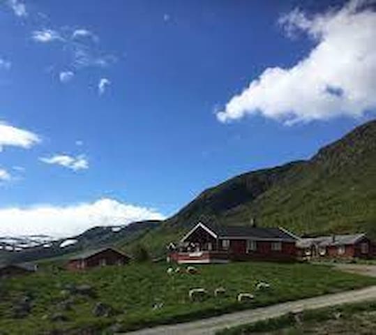
50min drive from cabin. On the start of Jotunheimen. Great starting point for both easy and advanced hiking in southern part of Jotunheimen
On site:
- Parking (paid)
- 2 hotels with cafe / restaurants
- Ferry on the lake
- Tourist info at the hotels
Hiking:
- Vinjeknappen 1433m, 370 altimeters, 2-2,5 hours round trip.
- Utsikten 1484m, 420 altimeters, 2 hours round trip.
- Tyinholmen-utsikten 1480m, 380 altimeters, 2 hours round trip.
- Torshammaren 1440m, 380 altimeters, 2 hours round trip.
- Sløtafjell 1406m, feel more like a hill then a peak but the view is worth it!
- Høgbrotet 1603m, 570 altimeters, 3,5-4 hours round trip.
- Gravafjell 1480m, 420 altimeters, 2,5 hours round trip.
Advanced hiking, guide strongly recommended:
- Falketind 2067m
- Langskaveltind 2014m
- Uranostinden 2157m
9 recommandé par les habitants
Eidsbugarden Hotel
Eidsbugardvegen50min drive from cabin. On the start of Jotunheimen. Great starting point for both easy and advanced hiking in southern part of Jotunheimen
On site:
- Parking (paid)
- 2 hotels with cafe / restaurants
- Ferry on the lake
- Tourist info at the hotels
Hiking:
- Vinjeknappen 1433m, 370 altimeters, 2-2,5 hours round trip.
- Utsikten 1484m, 420 altimeters, 2 hours round trip.
- Tyinholmen-utsikten 1480m, 380 altimeters, 2 hours round trip.
- Torshammaren 1440m, 380 altimeters, 2 hours round trip.
- Sløtafjell 1406m, feel more like a hill then a peak but the view is worth it!
- Høgbrotet 1603m, 570 altimeters, 3,5-4 hours round trip.
- Gravafjell 1480m, 420 altimeters, 2,5 hours round trip.
Advanced hiking, guide strongly recommended:
- Falketind 2067m
- Langskaveltind 2014m
- Uranostinden 2157m
8 min drive. Tyin Lake - perfect start for short scenic hikes with fantastic views
Popular easy to reach peaks:
- Hødntind
- Tyinstølsnøse
Tyin
8 min drive. Tyin Lake - perfect start for short scenic hikes with fantastic views
Popular easy to reach peaks:
- Hødntind
- Tyinstølsnøse
Just on your doorstep!
Wonderful terrain for easy walks.
Behind the cabin you find 'Børrenøse' and across the road 'Skørsnøse'
Paths for both hiking and cycling on your doorstep
Tyin Filefjell Mountain Resort, Jotunheimen - Norway
43 GrøvstølvegenJust on your doorstep!
Wonderful terrain for easy walks.
Behind the cabin you find 'Børrenøse' and across the road 'Skørsnøse'
Paths for both hiking and cycling on your doorstep
Startingpoint for walk along the Kings Road
https://www.visitkongevegen.com/adventures/hikes-and-walks/tyinkrysset-kyrkjestoelen/#
Nystuen
Startingpoint for walk along the Kings Road
https://www.visitkongevegen.com/adventures/hikes-and-walks/tyinkrysset-kyrkjestoelen/#
Starting point for walk along the Kings Road
https://www.visitkongevegen.com/adventures/hikes-and-walks/%C3%B8ye-stave-church-tyinkrysset/
Øye stavkirke
135 ØyevegenStarting point for walk along the Kings Road
https://www.visitkongevegen.com/adventures/hikes-and-walks/%C3%B8ye-stave-church-tyinkrysset/
Starting point for walk along the Kings Road
https://www.visitkongevegen.com/adventures/hikes-and-walks/kyrkjestoelen-maristova/
Kyrkjestølen
725 FilefjellsvegenStarting point for walk along the Kings Road
https://www.visitkongevegen.com/adventures/hikes-and-walks/kyrkjestoelen-maristova/
Startingpoint for walk on Kings Road - For the bendy road of Vindhella- (You may also start at the stavechurch)
https://www.visitkongevegen.com/adventures/hikes-and-walks/vindhellavegen/
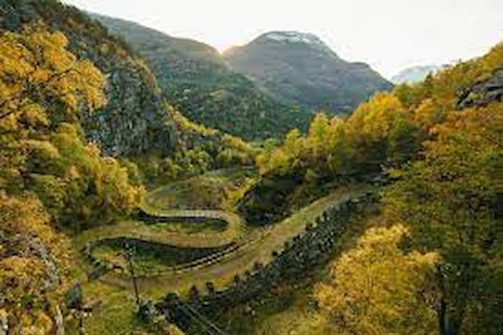
Rimskjold
Primær Fylkesvei 630Startingpoint for walk on Kings Road - For the bendy road of Vindhella- (You may also start at the stavechurch)
https://www.visitkongevegen.com/adventures/hikes-and-walks/vindhellavegen/
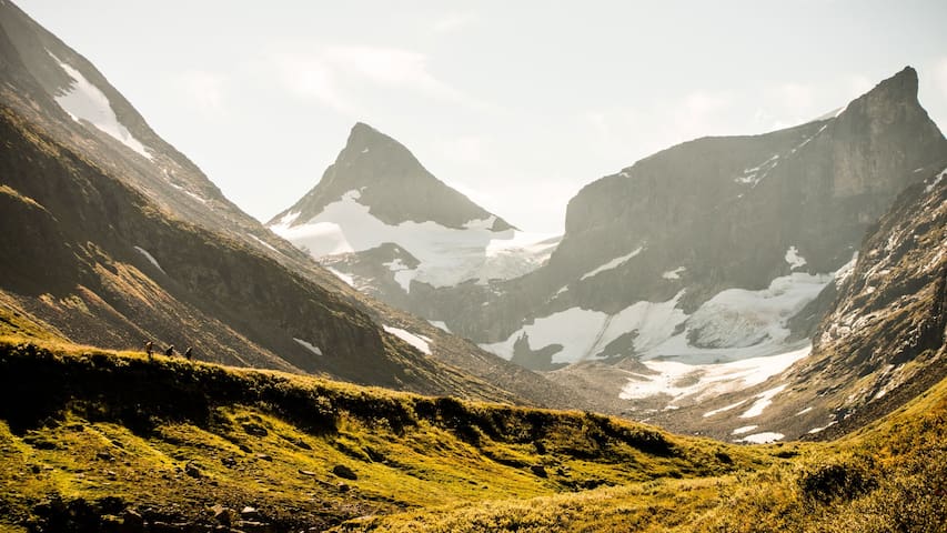
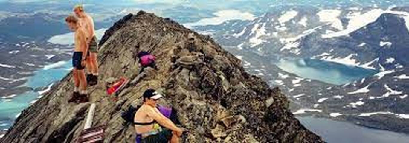
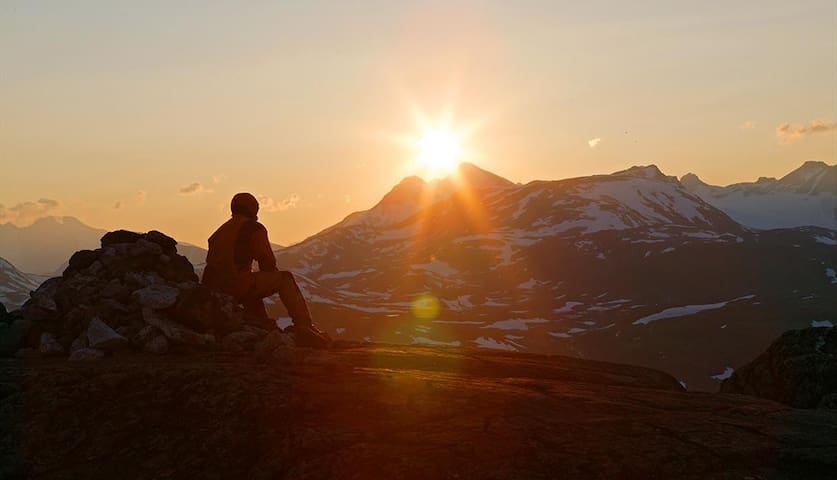
Advanced hikes. Guide necessary
Are you experienced with hiking at high altitudes, cross glaciers and equipped for a 10-12 hour round trip - do not miss the opportunity to ascend the great peaks of the southern Jotunheimen
It is probably the most demanding, and at the same time best tour in Jotunheimen! A wonderful tour including crossing a glacier on the way up to the 2067 meter high peak. The last part is very steep and will require some crawling. The view from the peak is breathtaking, and the route in itself is as well scenic. The tour starts in Koldedalen and set off for a 12-13km hike to the peak.
Several guided tours to the peak in summer.
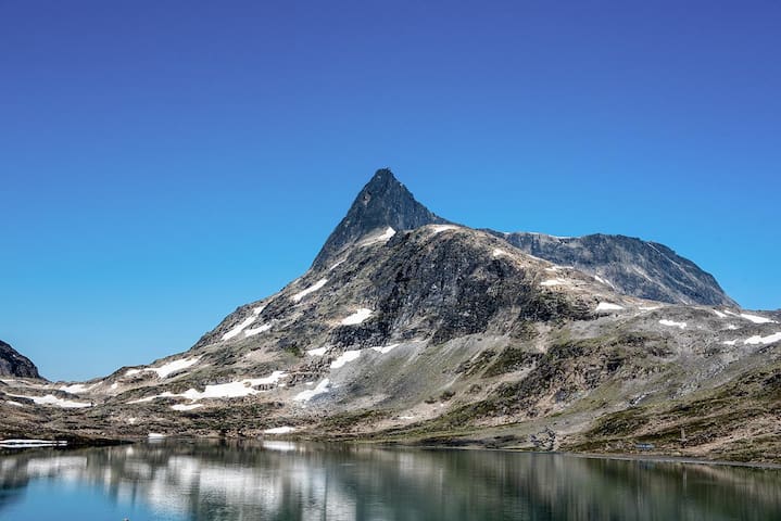
Falketind
It is probably the most demanding, and at the same time best tour in Jotunheimen! A wonderful tour including crossing a glacier on the way up to the 2067 meter high peak. The last part is very steep and will require some crawling. The view from the peak is breathtaking, and the route in itself is as well scenic. The tour starts in Koldedalen and set off for a 12-13km hike to the peak.
Several guided tours to the peak in summer.
This demanding 10-11 hour hike is great for experienced hikers. The trek takes you over crevasses, and you will do some easy climbing and then crawl out on the top ridge and admire the spectacular view from the summit. The weather at high altitudes in Norway can change quickly, and snowstorms can happen every month of the summer.
Urdanostindene
This demanding 10-11 hour hike is great for experienced hikers. The trek takes you over crevasses, and you will do some easy climbing and then crawl out on the top ridge and admire the spectacular view from the summit. The weather at high altitudes in Norway can change quickly, and snowstorms can happen every month of the summer.
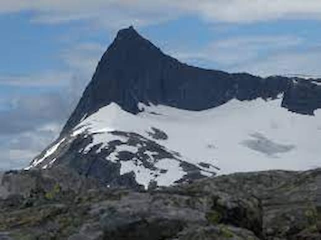
Langeskavlstind
Considred one of the 'easiest' 2k peaks. Climbing equipment needed to reach the top.
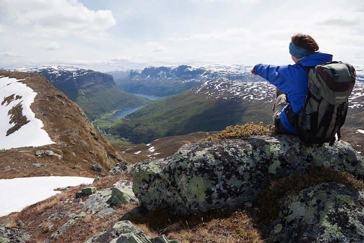
Easy hikes
Family friendly hikes, 1-4 hours. Perfect for a packed lunch, and breathtaking views! Walking boots and wind jacked recommended.
8 min drive. 1-2 hours walk. Maybe the best viewpoint with easy access in the area! Park along the road att the start of thee path.
Relatively easy hike with great view.
Length: approx. 5 km one way
Duration: approx. 1.5 hrs. up
Elevation gain: 400 meters
Suitable for children: from 5-6 yrs.
GPS-coordinates starting point 32v 459765 6789004
GPS-coordinates summit 32v 462673 6788158
Follow E16 to Tyinkrysset and exit onto road 53 towards Øvre Årdal. After 4 km, turn right on road 252 towards Eidsbugarden. After approx. 1 km, park your car on the left hand side of the road.
Follow the construction road towards Yljeosen where you turn right and follow the markings and cairns (with white V’s) towards Horntind. From the top we recommend following the mountain ridge for approx. 1-2 km Southeast where the view to the valley of Vang and Vangsmjøse is stunning.
Horntind
8 min drive. 1-2 hours walk. Maybe the best viewpoint with easy access in the area! Park along the road att the start of thee path.
Relatively easy hike with great view.
Length: approx. 5 km one way
Duration: approx. 1.5 hrs. up
Elevation gain: 400 meters
Suitable for children: from 5-6 yrs.
GPS-coordinates starting point 32v 459765 6789004
GPS-coordinates summit 32v 462673 6788158
Follow E16 to Tyinkrysset and exit onto road 53 towards Øvre Årdal. After 4 km, turn right on road 252 towards Eidsbugarden. After approx. 1 km, park your car on the left hand side of the road.
Follow the construction road towards Yljeosen where you turn right and follow the markings and cairns (with white V’s) towards Horntind. From the top we recommend following the mountain ridge for approx. 1-2 km Southeast where the view to the valley of Vang and Vangsmjøse is stunning.
Skørsnøse
Across the road from the cabin!
Børrenøse
Just behind the cabin. 30-45 min up. Perfect for a morning run or a even a sunset hike!
This is a short and family-friendly hike with a rewarding view of Tyin and Jotunheimen.
Length: approx. 2 km one way
Duration: approx. 30–45 min. up
Elevation gain: 300 meters
Suitable for children: from 4-5 yrs.
GPS-coordinates starting point 32v 457248 6791321
GPS-coordinates summit 32v 456260 6792149
Follow the E16 to Tyinkrysset and exit onto road 53 towards Øvre Årdal. Park at Tyinstølen.
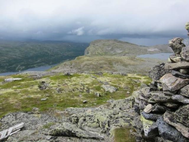
The route begins on the opposite side of the road. Follow the DNT trail (red T’s) from Tyinstølen towards Slettningsbu until you reach the mountain ridge. At the highest point of the route, turn right and follow the cairn markings to Tyinstølnøse. At the top you will find an information board with the names and elevations of all the 2000-meter peaks in Jotunheimen that are visible from here.
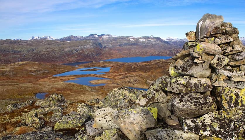
Tyinstølnøse
This is a short and family-friendly hike with a rewarding view of Tyin and Jotunheimen.
Length: approx. 2 km one way
Duration: approx. 30–45 min. up
Elevation gain: 300 meters
Suitable for children: from 4-5 yrs.
GPS-coordinates starting point 32v 457248 6791321
GPS-coordinates summit 32v 456260 6792149
Follow the E16 to Tyinkrysset and exit onto road 53 towards Øvre Årdal. Park at Tyinstølen.
The route begins on the opposite side of the road. Follow the DNT trail (red T’s) from Tyinstølen towards Slettningsbu until you reach the mountain ridge. At the highest point of the route, turn right and follow the cairn markings to Tyinstølnøse. At the top you will find an information board with the names and elevations of all the 2000-meter peaks in Jotunheimen that are visible from here.
Two peaks next to eachother: 'Skjenegge' and 'Utsikten'
Easy but rewarding ascend to the viewpoint "Utsikten" in the south-western part of Jotunheimen.
Length: approx. 3 km one way
Duration: approx. 1−1.5 hrs. up
Elevation gain: 425 meters to Utsikten
Suitable for children: from 4-5 yrs.
GPS-coordinates starting point 32v 462439 6804716
GPS-coordinates summit Utsikten 32v 462816 6802290
GPS-coordinates summit Skjenegge 32v 464423 6800779
Directions
Follow the E16 to Tyinkrysset and exit onto road 53 towards Øvre Årdal. After 4 km, turn right on road 252 to Eidsbugarden. Parking area near the Fondsbu DNT cabin (fee).
Description
At first, the route follows the DNT trail to Yksendalsbu (marked with red T’s). However, at the first crossing, the route to Utsikten continues to the right. Once you reach the top, Utsikten really lives up to its name, since “Utsikten” means “the view.” From there, you can continue further uphill towards the highest point on the ridge, Skjenegge. The panoramic view to Jotunheimen is sensational. Also, there’s a marked route from Tyinholmen to Utsikten.
Equiment
Walking shoes, appropriate clothing, maybe some snacks and something to drink
Skjenegge
Two peaks next to eachother: 'Skjenegge' and 'Utsikten'
Easy but rewarding ascend to the viewpoint "Utsikten" in the south-western part of Jotunheimen.
Length: approx. 3 km one way
Duration: approx. 1−1.5 hrs. up
Elevation gain: 425 meters to Utsikten
Suitable for children: from 4-5 yrs.
GPS-coordinates starting point 32v 462439 6804716
GPS-coordinates summit Utsikten 32v 462816 6802290
GPS-coordinates summit Skjenegge 32v 464423 6800779
Directions
Follow the E16 to Tyinkrysset and exit onto road 53 towards Øvre Årdal. After 4 km, turn right on road 252 to Eidsbugarden. Parking area near the Fondsbu DNT cabin (fee).
Description
At first, the route follows the DNT trail to Yksendalsbu (marked with red T’s). However, at the first crossing, the route to Utsikten continues to the right. Once you reach the top, Utsikten really lives up to its name, since “Utsikten” means “the view.” From there, you can continue further uphill towards the highest point on the ridge, Skjenegge. The panoramic view to Jotunheimen is sensational. Also, there’s a marked route from Tyinholmen to Utsikten.
Equiment
Walking shoes, appropriate clothing, maybe some snacks and something to drink
Not to miss in the area!
Exeptional experiences within driving distance
Église en bois debout de Borgund
606 Vindhellavegen