
Tina’s Guidebook
Food scene
Closest pub to the cabin...approx 20 mins walk or 5 mins drive
The Old Pandy Inn & Black Mountain bunkhouse
Hereford RoadClosest pub to the cabin...approx 20 mins walk or 5 mins drive
Situated in nearest village (2.0 miles)
The inn is one of a number of pubs claiming to be the oldest in Wales. Work undertaken by the Glamorgan-Gwent Archaeological Trust has concluded that the present building is of mainly mid-late 17th century construction. However, Forde presents the theory that an inn had stood on the site previously, due to it being situated upon a pilgrim trail that led to Llanthony Priory; although there is no evidence to verify this.
A popular, although equally unverified, legend is that the inn was used as a rallying point for local supporters of the Glyndŵr Rising against the rule of Henry IV, the uprising being led by Owain Glyndŵr. He is said to have personally rallied his troops in the cobbled courtyard before raiding nearby settlements sympathetic to the English in the 15th century.
Another undocumented claim to fame is that the first floor of the inn was reputedly used as a Court of Law where capital punishment was imposed for certain offences, including sheep stealing. Legend has it that as many as 180 criminals were adjudged guilty of crimes serious enough to warrant the sentence of death by hanging, a sentence that was allegedly carried out at the inn itself, from an oak beam over the well of the staircase. Markings, said to be from rope marks, still exist on the staircase wood.
The inn has, largely based on these unverified and undocumented stories, gained a reputation for being haunted by several ghosts or spirits and has been said to be the scene of numerous supernatural occurrences or paranormal activities. The inn was featured in series one of the television show Extreme Ghost Stories, and series two of Most Haunted with Yvette Fielding.
20 recommandé par les habitants
The Skirrid Mountain Inn
Situated in nearest village (2.0 miles)
The inn is one of a number of pubs claiming to be the oldest in Wales. Work undertaken by the Glamorgan-Gwent Archaeological Trust has concluded that the present building is of mainly mid-late 17th century construction. However, Forde presents the theory that an inn had stood on the site previously, due to it being situated upon a pilgrim trail that led to Llanthony Priory; although there is no evidence to verify this.
A popular, although equally unverified, legend is that the inn was used as a rallying point for local supporters of the Glyndŵr Rising against the rule of Henry IV, the uprising being led by Owain Glyndŵr. He is said to have personally rallied his troops in the cobbled courtyard before raiding nearby settlements sympathetic to the English in the 15th century.
Another undocumented claim to fame is that the first floor of the inn was reputedly used as a Court of Law where capital punishment was imposed for certain offences, including sheep stealing. Legend has it that as many as 180 criminals were adjudged guilty of crimes serious enough to warrant the sentence of death by hanging, a sentence that was allegedly carried out at the inn itself, from an oak beam over the well of the staircase. Markings, said to be from rope marks, still exist on the staircase wood.
The inn has, largely based on these unverified and undocumented stories, gained a reputation for being haunted by several ghosts or spirits and has been said to be the scene of numerous supernatural occurrences or paranormal activities. The inn was featured in series one of the television show Extreme Ghost Stories, and series two of Most Haunted with Yvette Fielding.
City/town information
Llanthony Priory is situated here. This dates back to about 1100 when a Norman nobleman Walter de Lacy was inspired by an existing chapel to devote himself to solitary prayer and study. He was joined by others and a church was built on the site in 1108. By 1118, a group of about forty monks from England built the priory of Canons Regular, the first in Wales. It was constantly being raided by the Welsh and was soon in decline, and after Owain Glyndŵr's rebellion in the early 15th century, it seems to have become barely functioning. In 1481 it was formally merged with its daughter monastery at Gloucester then was later suppressed by Henry VIII's Dissolution of the Monasteries
The Priory became one of the great medieval buildings in Wales, being built in a mixture of Norman and Gothic architectural styles. It is a Grade I Listed building, being "an important medieval monastic ruin with high quality surviving detail."
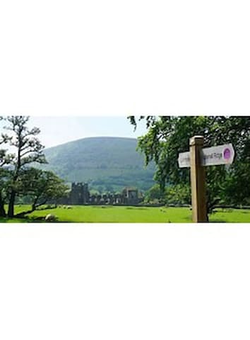
The area is popular for hillwalking, pony trekking, Horseback riding and mountain biking. The Offa's Dyke Path passes above on the ridge which forms the border between England and Wales.
30 recommandé par les habitants
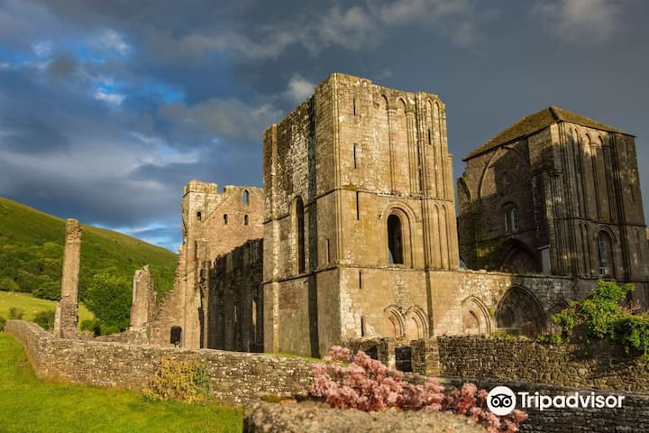
Llanthony
Llanthony Priory is situated here. This dates back to about 1100 when a Norman nobleman Walter de Lacy was inspired by an existing chapel to devote himself to solitary prayer and study. He was joined by others and a church was built on the site in 1108. By 1118, a group of about forty monks from England built the priory of Canons Regular, the first in Wales. It was constantly being raided by the Welsh and was soon in decline, and after Owain Glyndŵr's rebellion in the early 15th century, it seems to have become barely functioning. In 1481 it was formally merged with its daughter monastery at Gloucester then was later suppressed by Henry VIII's Dissolution of the Monasteries
The Priory became one of the great medieval buildings in Wales, being built in a mixture of Norman and Gothic architectural styles. It is a Grade I Listed building, being "an important medieval monastic ruin with high quality surviving detail."
The area is popular for hillwalking, pony trekking, Horseback riding and mountain biking. The Offa's Dyke Path passes above on the ridge which forms the border between England and Wales.
Nearest city 18 miles away
Hereford (/ˈhɛrɪfərd/ (listen)) is a cathedral city, civil parish and the county town of Herefordshire, England. It lies on the River Wye, approximately 16 miles (26 km) east of the border with Wales, 24 miles (39 km) south-west of Worcester and 23 miles (37 km) north-west of Gloucester. With a population of 60,800,[2] it is by far the largest settlement in Herefordshire.
An early town charter from 1189, granted by Richard I of England, describes it as "Hereford in Wales".[3] Hereford has been recognised as a city since time immemorial, with the status being reconfirmed as recently as October 2000.[4][5]
It is now known chiefly as a trading centre for a wider agricultural and rural area. Products from Hereford include cider, beer, leather goods, nickel alloys, poultry, chemicals and sausage rolls, as well as the famous Hereford breed of cattle.
157 recommandé par les habitants
Hereford
Nearest city 18 miles away
Hereford (/ˈhɛrɪfərd/ (listen)) is a cathedral city, civil parish and the county town of Herefordshire, England. It lies on the River Wye, approximately 16 miles (26 km) east of the border with Wales, 24 miles (39 km) south-west of Worcester and 23 miles (37 km) north-west of Gloucester. With a population of 60,800,[2] it is by far the largest settlement in Herefordshire.
An early town charter from 1189, granted by Richard I of England, describes it as "Hereford in Wales".[3] Hereford has been recognised as a city since time immemorial, with the status being reconfirmed as recently as October 2000.[4][5]
It is now known chiefly as a trading centre for a wider agricultural and rural area. Products from Hereford include cider, beer, leather goods, nickel alloys, poultry, chemicals and sausage rolls, as well as the famous Hereford breed of cattle.
Sightseeing
Closest larger town ( 6 miles away)
Abergavenny (/ˌæbərɡəˈvɛni/; Welsh: Y Fenni pronounced [ə ˈvɛnɪ], archaically Abergafenni meaning "mouth of the River Gavenny") is a market town and community in Monmouthshire, Wales. Abergavenny is promoted as a Gateway to Wales; it is approximately 6 miles (10 km) from the border with England and is located where the A40 trunk road and the A465 Heads of the Valleys road meet.
Originally the site of a Roman fort, Gobannium, it became a medieval walled town within the Welsh Marches. The town contains the remains of a medieval stone castle built soon after the Norman conquest of Wales.
Abergavenny is situated at the confluence of the River Usk and a tributary stream, the Gavenny. It is almost entirely surrounded by mountains and hills: the Blorenge (559 m, 1,834 ft),[4] the Sugar Loaf (596 m, 1,955 ft), Ysgyryd Fawr (Great Skirrid), Ysgyryd Fach (Little Skirrid), Deri, Rholben and Mynydd Llanwenarth, known locally as "Llanwenarth Breast". Abergavenny provides access to the nearby Black Mountains and the Brecon Beacons National Park. The Marches Way and Beacons Way pass through Abergavenny whilst the Offa's Dyke Path passes through Pandy five miles to the north and the Usk Valley Walk passes through nearby Llanfoist.
145 recommandé par les habitants
Abergavenny
Closest larger town ( 6 miles away)
Abergavenny (/ˌæbərɡəˈvɛni/; Welsh: Y Fenni pronounced [ə ˈvɛnɪ], archaically Abergafenni meaning "mouth of the River Gavenny") is a market town and community in Monmouthshire, Wales. Abergavenny is promoted as a Gateway to Wales; it is approximately 6 miles (10 km) from the border with England and is located where the A40 trunk road and the A465 Heads of the Valleys road meet.
Originally the site of a Roman fort, Gobannium, it became a medieval walled town within the Welsh Marches. The town contains the remains of a medieval stone castle built soon after the Norman conquest of Wales.
Abergavenny is situated at the confluence of the River Usk and a tributary stream, the Gavenny. It is almost entirely surrounded by mountains and hills: the Blorenge (559 m, 1,834 ft),[4] the Sugar Loaf (596 m, 1,955 ft), Ysgyryd Fawr (Great Skirrid), Ysgyryd Fach (Little Skirrid), Deri, Rholben and Mynydd Llanwenarth, known locally as "Llanwenarth Breast". Abergavenny provides access to the nearby Black Mountains and the Brecon Beacons National Park. The Marches Way and Beacons Way pass through Abergavenny whilst the Offa's Dyke Path passes through Pandy five miles to the north and the Usk Valley Walk passes through nearby Llanfoist.
The Brecon Beacons National Park was established in 1957, the last of the three Welsh parks designated after Snowdonia in 1951 and the Pembrokeshire Coast in 1952. It stretches from Llandeilo in the west to Hay-on-Wye in the northeast and Pontypool in the southeast, covering 519 square miles (1,340 km2) and encompassing four main regions – the Black Mountain in the west, reaching 802 metres (2631 feet) at Fan Brycheiniog, Fforest Fawr and the Brecon Beacons in the centre, including the highest summit in the park and in South Wales at Pen y Fan 886 metres (2,907 feet) and the confusingly named Black Mountains in the east, where the highest point is Waun Fach 811 metres (2,661 feet). The western half gained European and global status in 2005[1] as Fforest Fawr Geopark. This includes the Black Mountain, the historic extent of Fforest Fawr, and much of the Brecon Beacons and surrounding lowlands.
279 recommandé par les habitants
Brecon Beacons
Beacons ParkThe Brecon Beacons National Park was established in 1957, the last of the three Welsh parks designated after Snowdonia in 1951 and the Pembrokeshire Coast in 1952. It stretches from Llandeilo in the west to Hay-on-Wye in the northeast and Pontypool in the southeast, covering 519 square miles (1,340 km2) and encompassing four main regions – the Black Mountain in the west, reaching 802 metres (2631 feet) at Fan Brycheiniog, Fforest Fawr and the Brecon Beacons in the centre, including the highest summit in the park and in South Wales at Pen y Fan 886 metres (2,907 feet) and the confusingly named Black Mountains in the east, where the highest point is Waun Fach 811 metres (2,661 feet). The western half gained European and global status in 2005[1] as Fforest Fawr Geopark. This includes the Black Mountain, the historic extent of Fforest Fawr, and much of the Brecon Beacons and surrounding lowlands.
Big Pit National Coal Museum (Welsh: Pwll Mawr Amgueddfa Lofaol Cymru) is an industrial heritage museum in Blaenavon, Torfaen, Wales. A working coal mine from 1880 to 1980, it was opened to the public in 1983 as a charitable trust called the Big Pit (Blaenavon) Trust. By 1 February 2001 Big Pit Coal Museum was incorporated into the National Museum and Galleries of Wales as the National Mining Museum of Wales. The site is dedicated to operational preservation of the Welsh heritage of coal mining, which took place during the Industrial Revolution.
Located adjacent to the preserved Pontypool and Blaenavon Railway, Big Pit is part of the Blaenavon Industrial Landscape, a World Heritage Site, and an Anchor Point of the European Route of Industrial Heritage.
13 recommandé par les habitants
Big Pit Mining Museum
Forge SideBig Pit National Coal Museum (Welsh: Pwll Mawr Amgueddfa Lofaol Cymru) is an industrial heritage museum in Blaenavon, Torfaen, Wales. A working coal mine from 1880 to 1980, it was opened to the public in 1983 as a charitable trust called the Big Pit (Blaenavon) Trust. By 1 February 2001 Big Pit Coal Museum was incorporated into the National Museum and Galleries of Wales as the National Mining Museum of Wales. The site is dedicated to operational preservation of the Welsh heritage of coal mining, which took place during the Industrial Revolution.
Located adjacent to the preserved Pontypool and Blaenavon Railway, Big Pit is part of the Blaenavon Industrial Landscape, a World Heritage Site, and an Anchor Point of the European Route of Industrial Heritage.
Black Mountains Cycle Centre
Offa's Dyke Path (Welsh: Llwybr Clawdd Offa) is a long-distance footpath loosely following the Wales–England border. Officially opened on 10 July 1971, by Lord Hunt, it is one of Britain's National Trails and draws walkers from throughout the world. About 60 miles (97 km) of the 177-mile (285 km) route either follows, or keeps close company with, the remnants of Offa's Dyke, an earthwork traditionally thought to have been constructed in the late 8th century on the orders of King Offa of Mercia.
Traveling south to north, starting by the Severn Estuary at Sedbury, near Chepstow, and finishing at Prestatyn on the north coast, the walk will take an average walker roughly 12 days to complete. Roughly following the border in parts, and elsewhere the ancient monument of Offa's Dyke, as well as natural features such as the Hatterrall Ridge, the Dyke Path passes through a variety of landscapes. The route traces the eastern edge of the Black Mountains, traverses Clun Forest, the Eglwyseg moors north of Llangollen and the Clwydian Range.
The route passes through the counties of Monmouthshire, Gloucestershire, Powys, Herefordshire, Shropshire, Wrexham, Denbighshire and Flintshire. The Welsh Marches (Marchia Wallie) is a term used to describe this border region between England and Wales, since it was recorded in the Domesday Book in 1086.. It passes through, or close to, the towns of Chepstow, Monmouth, Hay-on-Wye, Kington, Presteigne, Knighton, Montgomery, Welshpool and Oswestry, then in and around the North Wales towns and villages of Llangollen, Llandegla, Bodfari and Dyserth.
The half-way point of the path is marked by the Offa's Dyke Centre in Knighton (52.3458°N 3.0517°WCoordinates: 52.3458°N 3.0517°W).[5] There used to be around 600 stiles along the route, but many of these have now been replaced by kissing gates.
a certain vigorous king called Offa......had a great dyke built between Wales and Mercia from sea to sea.
— Asser
Offa's Dyke Path
Offa's Dyke PathOffa's Dyke Path (Welsh: Llwybr Clawdd Offa) is a long-distance footpath loosely following the Wales–England border. Officially opened on 10 July 1971, by Lord Hunt, it is one of Britain's National Trails and draws walkers from throughout the world. About 60 miles (97 km) of the 177-mile (285 km) route either follows, or keeps close company with, the remnants of Offa's Dyke, an earthwork traditionally thought to have been constructed in the late 8th century on the orders of King Offa of Mercia.
Traveling south to north, starting by the Severn Estuary at Sedbury, near Chepstow, and finishing at Prestatyn on the north coast, the walk will take an average walker roughly 12 days to complete. Roughly following the border in parts, and elsewhere the ancient monument of Offa's Dyke, as well as natural features such as the Hatterrall Ridge, the Dyke Path passes through a variety of landscapes. The route traces the eastern edge of the Black Mountains, traverses Clun Forest, the Eglwyseg moors north of Llangollen and the Clwydian Range.
The route passes through the counties of Monmouthshire, Gloucestershire, Powys, Herefordshire, Shropshire, Wrexham, Denbighshire and Flintshire. The Welsh Marches (Marchia Wallie) is a term used to describe this border region between England and Wales, since it was recorded in the Domesday Book in 1086.. It passes through, or close to, the towns of Chepstow, Monmouth, Hay-on-Wye, Kington, Presteigne, Knighton, Montgomery, Welshpool and Oswestry, then in and around the North Wales towns and villages of Llangollen, Llandegla, Bodfari and Dyserth.
The half-way point of the path is marked by the Offa's Dyke Centre in Knighton (52.3458°N 3.0517°WCoordinates: 52.3458°N 3.0517°W).[5] There used to be around 600 stiles along the route, but many of these have now been replaced by kissing gates.
a certain vigorous king called Offa......had a great dyke built between Wales and Mercia from sea to sea.
— Asser